$53.51
Add to Cart
Garmin BlueChart g2 Vision HD VUS038R - New York - Chesapeake - microSD/SD
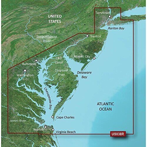


Garmin BlueChart g2 Vision HD-VUS038R-New York-Chesapeake-microSD/SDBlueChart® g2 Vision® HD - VUS038R - New York - Chesapeake - microSD™/SD™ Package includes: preprogrammed Micro SD card with an optional full size SD adapter, protective case.Works in GPS models listed in the compatible device list.You may use HomePort on your computer with this digital map to plan your routes/trips.At checkout, leave us a message/note indicating your GPS model. Domestic shipping is via USPS first class with tracking, expedited shipping is available. Features on BlueChart g2:· · Includes realistic navigation features showing everything from shaded depth contours and coastlines to spot soundings, navaids, port plans, wrecks, obstructions, intertidal zones, restricted areas, IALA symbols and more.· Features smooth displays, including seamless transitions between zoom levels and more continuity across chart boundaries.· Allows users to choose between standard 2-D direct overhead or 3-D "over the bow" map perspective to make chart reading and orientation easier.· Provides Safety Shading (in compatible units), allowing mariners to enable contour shading for all depth contours shallower than user-defined safe depths.· Provides Fishing Charts (in compatible units), allowing mariners to scope out bottom contours and depth soundings with less visual clutter on the display. Coverage:Raritan Bay to Virginia Beach including Tarrytown, Fire Island Inlet, the entire New Jersey coastline, the C&D Canal, Delaware Bay, the Delaware River to Trenton, Chesapeake Bay, Baltimore, the Potomac River to Washington D.C., Chincoteague Bay, Cape Charles, Newport News, and Norfolk.Premier Coastal Navigation ChartsProvides industry-leading coverage, clarity and detail with updated coastal charts that feature integrated Garmin and Navionics® dataAuto Guidance¹ technology uses your desired depth and overhead clearance to calculate routes and show a suggested path to followHigh-resolution relief shading combines color and shadow to give you an easy-to-interpret, clearer view of bottom structure than contour lines aloneDepth Range Shading provides up to 10 depth ranges, enabling you to view your target depth at a glanceUp to 1’ contours provide a more accurate depiction of the bottom structure for improved fishing charts and navigation in swamps, canals and marinasExperience unparalleled coverage and brilliant detail on the water. BlueChart g2 Vision coastal charts provide industry-leading coverage, clarity and detail with integrated Garmin and Navionics data, Auto Guidance technology and high-resolution relief shading.. Compatible Devices: Alpha® 100Astro® 320 / 430Dakota® 20eTrex® 20 / 30 / Touch 25 / Touch 35 / Touch 35t echoMAP™ 43dv / 44dv / 50dv / 50s / 53cv / 53dv / 54dv / 70dv / 70s / 73dv / 73sv / 74sv / 93sv / 94sv echoMAP™ CHIRP 42cv / 42dv / 43cv / 43dv / 44cv / 44dv / 45cv / 45dv / 52cv / 52dv / 53cv / 53dv / 54cv / 54dv / 55cv / 55dv / 72cv / 72dv / 72sv / 73cv / 73dv / 73sv / 74cv // 74sv / 75cv / 75dv / 75sv / 92sv / 93sv / 94sv / 95svNOT for the echoMAP Plus and echomap UHD series! GPSMAP 276Cx / 4008 / 4010 / 4012 / 4208 / 420/420s / 421 / 4210 / 4212 / 431 / 431s / 441 / 441s / 5008 / 5012 / 5015 / 5208 / 521 / 5212 / 5215 / 520/520s / 521s / 526 / 526s / 531 / 531s / 536 / 536s / 541 / 541s / 545/545s / 546 / 546s / 62 / 6208 / 6212 / 62s / 62sc / 62st / 62stc / 64s / 64st / 640 / 66s / 720 / 720s / 721xs / 7212 / 7215 / / 7407 / 7407xsv / 7408 / 7408xsv / / / 741xs / 7410 / 7412 / 7416 / 7607 / 7607xsv / 7608 / 7610 / 7612 / 7616 / 78 / 78s / 78sc / 840xs / 86i / 86s / 86sc / 1020xs / 1040xs Colorado® 300 / 400c / 400i / 400t Montana® 600 / 600t / 610 / 610t / 650 / 650t / 680 / 680tMonterra Oregon® 450 / 450t / 550 / 550t / 600 / 600t / 650 / 650t/750/750t Rino® 750 / 755tAuto Guidance TechnologyThe Auto Guidance feature¹ uses your desired depth and overhead clearance to calculate a route and a suggested path to follow.High-resolution Relief Shading FeatureHigh-resolution relief shading combines color and shadow to give you an easy-to-interpret, clearer view of bottom structure than contour lines alone.Up to 1’ ContoursThe closer the contour lines, the more accurate the depiction of the bottom structure for improved fishing charts and navigation in swamps, canals and marinas.NOAA Raster CartographyIf you prefer your display to have the look of paper charts, NOAA raster cartography2 is available as a free downloadable feature via the ActiveCaptain® app.Depth Range ShadingThis feature provides up to 10 depth ranges, enabling you to view your target depth at a glance.Shallow Water ShadingThis feature allows you to use shading to designate the shallow water depths you need to avoid.High-resolution Satellite ImageryThese detailed images of ports, marinas, bridges and navigational landmarks help provide you with superior situational awareness.Unique 3-D ViewsMarinerEye and FishEye views provide additional perspective both above and below the water line.¹Auto Guidance is for planning purposes only and does not replace safe navigation operations ²Raster cartography cannot be viewed on echoMAP CHIRP and ECHOMAP Plus combos but can be viewed on mobile devices via the ActiveCaptain mobile appWARNING: This product can expose you to chemicals which are known to the State of California to cause cancer, birth defects or other reproductive harm. For more information go to P65Warnings.ca.gov.This product may not be returned to the original point of purchase. Please contact the manufacturer directly with any issues or concerns.


