$51.97
Add to Cart
VUS038R Garmin BlueChart g2 HD Vision HD--New York-Chesapeake-microSD/SD
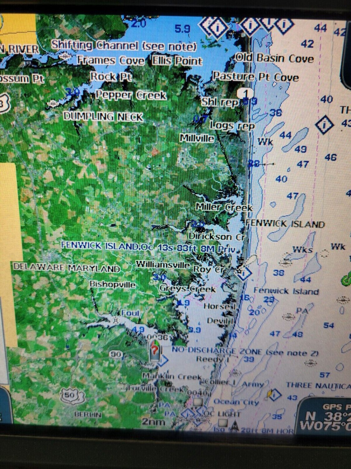


Explore the Seas with Garmin BlueChart g2 Vision HD-VUS038R for New York to Chesapeake! Enhance your maritime adventures with the Garmin BlueChart g2 Vision HD-VUS038R microSD/SD card. Packed with features, this digital map offers unparalleled coverage and detail, ensuring you navigate the waters with confidence. Key Benefits: Comprehensive Coverage: From Raritan Bay to Virginia Beach, including Tarrytown, Fire Island Inlet, the entire New Jersey coastline, the Chesapeake Bay, and more, this chart provides industry-leading coverage, clarity, and detail. Advanced Navigation Features: Seamlessly transition between zoom levels, choose between 2-D or 3-D perspective, and enable Safety Shading and Fishing Charts for enhanced navigation. Compatibility: Works with a wide range of Garmin GPS models, including Alpha®, Astro®, Dakota®, eTrex®, echoMAP™, GPSMAP®, Colorado®, Montana®, Monterra, Oregon®, and Rino® devices Alpha® 100 Astro® 320 / 430 Dakota® 20 eTrex® 20 / 30 / Touch 25 / Touch 35 / Touch 35t echoMAP™ 43dv / 44dv / 50dv / 50s / 53cv / 53dv / 54dv / 70dv / 70s / 73dv / 73sv / 74sv / 93sv / 94sv echoMAP™ CHIRP 42cv / 42dv / 43cv / 43dv / 44cv / 44dv / 45cv / 45dv / 52cv / 52dv / 53cv / 53dv / 54cv / 54dv / 55cv / 55dv / 72cv / 72dv / 72sv / 73cv / 73dv / 73sv / 74cv / 74dv / 74sv / 75cv / 75dv / 75sv / 92sv / 93sv / 94sv / 95sv NOT for the echoMAP Plus and echomap UHD series! GPSMAP 276Cx / 4008 / 4010 / 4012 / 4208 / 420/420s / 421 / 4210 / 4212 / 431 / 431s / 441 / 441s / 5008 / 5012 / 5015 / 5208 / 521 / 5212 / 5215 / 520/520s / 521s / 526 / 526s / 531 / 531s / 536 / 536s / 541 / 541s / 545/545s / 546 / 546s / 62 / 6208 / 6212 / 62s / 62sc / 62st / 62stc / 64s / 64st / 640 / 66s / 720 / 720s / 721xs / 7212 / 7215 / 740 / 7407 / 7407xsv / 7408 / 7408xsv / 740s / 741 / 741xs / 7410 / 7412 / 7416 / 7607 / 7607xsv / 7608 / 7610 / 7612 / 7616 / 78 / 78s / 78sc / 840xs / 86i / 86s / 86sc / 1020xs / 1040xs Colorado® 300 / 400c / 400i / 400t Montana® 600 / 600t / 610 / 610t / 650 / 650t / 680 / 680t Monterra Oregon® 450 / 450t / 550 / 550t / 600 / 600t / 650 / 650t/750/750t Rino® 750 / 755t Auto Guidance Technology: Plan your routes effortlessly using desired depth and overhead clearance, with Auto Guidance suggesting the safest paths. High-Resolution Relief Shading: Gain a clearer view of bottom structures with detailed relief shading, improving navigation in swamps, canals, and marinas. NOAA Raster Cartography: For a traditional chart display, access NOAA raster cartography via the ActiveCaptain® app on mobile devices. Safety Warning: Be aware of shallow waters and potential hazards with features like Depth Range Shading and Shallow Water Shading. High-Resolution Satellite Imagery: Get detailed views of ports, marinas, and landmarks for superior situational awareness. Unique 3-D Views: Explore both above and below the water line with MarinerEye and FishEye perspectives. This package includes a preprogrammed Micro SD card with an optional full-size SD adapter and a protective case. Enjoy domestic shipping via USPS first class with tracking, with expedited shipping options available. Upgrade your boating experience today with the Garmin BlueChart g2 Vision HD-VUS038R and sail with confidence. Leave a message at checkout indicating your GPS model for seamless compatibility. Happy sailing!


