
$419.69
Add to Cart
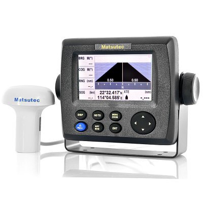
Marine GPS / SBAS Navigator "Matsutec HP-33" - 4.3 Inch Screen, 10.000 Waypoints


5 available
Details
Shipping: Australia: free (more destinations)
Sales Tax: check
Condition: Brand new
*The store has not been updated recently. You may want to contact the merchant to confirm the availability of the product.
Marine GPS/SBAS Navigator with 4.3 Inch Screen, 10.000 Waypoints Save, 5 display modes and more.
Designed for a wide range of vessels such as coastal ships, fishing boats and pleasure crafts, the “Matsutec HP33” is an advanced marine GPS navigator with SBAS receiver. Providing accurate and reliable position fixing thanks to the 50-channel GPS receiver with integrated SBAS technology, position can be calculated up to 2 meters precise. Its large 4.3 Inch color waterproof display and durable case are designed to stand up to tough marine conditions and can be covered up with the provided protector.
Coming with an impressive built-in memory, the “Matsutec HP-33” is capable of storing up to 3000 track points, 10000 waypoints and 100 routes of up to 30 waypoints each. The “Matsutec HP33” provides navigation data and displays them in a wide variety of numerical and geographic formats preferred by the user. Switch between Plotter, Highway, Steering, Navigation Data, Satellite, and two user defined modes using the easy to use controls.
with a 12 month warranty. Brought to you by the leader in wholesale GPS technology, Chinavasion.
At a Glance...
Marine GPS Navigator with SBAS
4.3 Inch Waterproof Screen
Save up to 10000 Waypoints, 3000 Trackpoints and 100 Routes
7 Display Modes
Manufacturer Specifications
General
Display Mode: Plotter, Highway, Steering, Nav Data, Satellite, User Display1, User Display2
Alarm: Arrival, Anchor Watch, XTE, Speed, SBAS, Time, Trip, Odometer
Projection: Mercator Projection
Plot Scale: 0.01nm - 320nm
Power Source: 12-24 VDC, 0.24-0.12A
GPS/SBAS
GPS: 50 Channels, C/A Code
SBAS: WAAS, EGNOS, MSAS, GAGAN
Receive Frequency: L1 (1575.42 MHz)
Cold Start: 32s
Hot Start: 1s
Tracking Velocity: 500m/s
Altitude: 50000m Max
Dynamics: 4G Max
Geodetic Systems: WGS-84 (and Others)
Horizontal GPS Accuracy: 2.5m
Horizontal SBAS Accuracy: 2.0m
Velocity Accuracy: 0.1m/s
Heading Accuracy: 0.5 Degrees
Display
Display Size: 4.3 Inch Color LCD
Display Resolution: 480x272
Brightness: 500cd
Non Touch Display
Memory
3000 Ship Track Points
10,000 Marks and Waypoints With Comments
100 Routes, 30 Waypoints/Routes
Ports
REM1: DTM, GGA, GLL, RMB, RMC, VTG, ZDA
REM2: BWC, DTM, GGA, RMB, RMC, VTG, ZDA
AP: AAM, APB, BOD, BWC, BWR, GLL, VTG, XTE, ZDA
GPS: GGA, GSA, GSV, VTG
Dimensions
Main product dimensions: 150x140x80mm (L x W x D)
Main product weight: 800g
Weight/dimension is for the main item of this boxed product, to help you compare product sizes before buying: please do not base your shipping calculations on this price - shipping prices depend on your cart contents, shipping destination, and shipping method: please use the checkout to select options and preview shipping price for your total order.
Designed for a wide range of vessels such as coastal ships, fishing boats and pleasure crafts, the “Matsutec HP33” is an advanced marine GPS navigator with SBAS receiver. Providing accurate and reliable position fixing thanks to the 50-channel GPS receiver with integrated SBAS technology, position can be calculated up to 2 meters precise. Its large 4.3 Inch color waterproof display and durable case are designed to stand up to tough marine conditions and can be covered up with the provided protector.
Coming with an impressive built-in memory, the “Matsutec HP-33” is capable of storing up to 3000 track points, 10000 waypoints and 100 routes of up to 30 waypoints each. The “Matsutec HP33” provides navigation data and displays them in a wide variety of numerical and geographic formats preferred by the user. Switch between Plotter, Highway, Steering, Navigation Data, Satellite, and two user defined modes using the easy to use controls.
with a 12 month warranty. Brought to you by the leader in wholesale GPS technology, Chinavasion.
At a Glance...
Marine GPS Navigator with SBAS
4.3 Inch Waterproof Screen
Save up to 10000 Waypoints, 3000 Trackpoints and 100 Routes
7 Display Modes
Manufacturer Specifications
General
Display Mode: Plotter, Highway, Steering, Nav Data, Satellite, User Display1, User Display2
Alarm: Arrival, Anchor Watch, XTE, Speed, SBAS, Time, Trip, Odometer
Projection: Mercator Projection
Plot Scale: 0.01nm - 320nm
Power Source: 12-24 VDC, 0.24-0.12A
GPS/SBAS
GPS: 50 Channels, C/A Code
SBAS: WAAS, EGNOS, MSAS, GAGAN
Receive Frequency: L1 (1575.42 MHz)
Cold Start: 32s
Hot Start: 1s
Tracking Velocity: 500m/s
Altitude: 50000m Max
Dynamics: 4G Max
Geodetic Systems: WGS-84 (and Others)
Horizontal GPS Accuracy: 2.5m
Horizontal SBAS Accuracy: 2.0m
Velocity Accuracy: 0.1m/s
Heading Accuracy: 0.5 Degrees
Display
Display Size: 4.3 Inch Color LCD
Display Resolution: 480x272
Brightness: 500cd
Non Touch Display
Memory
3000 Ship Track Points
10,000 Marks and Waypoints With Comments
100 Routes, 30 Waypoints/Routes
Ports
REM1: DTM, GGA, GLL, RMB, RMC, VTG, ZDA
REM2: BWC, DTM, GGA, RMB, RMC, VTG, ZDA
AP: AAM, APB, BOD, BWC, BWR, GLL, VTG, XTE, ZDA
GPS: GGA, GSA, GSV, VTG
Dimensions
Main product dimensions: 150x140x80mm (L x W x D)
Main product weight: 800g
Weight/dimension is for the main item of this boxed product, to help you compare product sizes before buying: please do not base your shipping calculations on this price - shipping prices depend on your cart contents, shipping destination, and shipping method: please use the checkout to select options and preview shipping price for your total order.


